CO₂ Pipeline Meetings Come to Bloomington Oct. 15, but Residents Unlikely to Learn Whether They'd Be Safe
About 1,700 homes, schools, and a hospital lie within the pipeline's two-mile emergency planning zone, but One Earth has released no modeling or risk assessment.
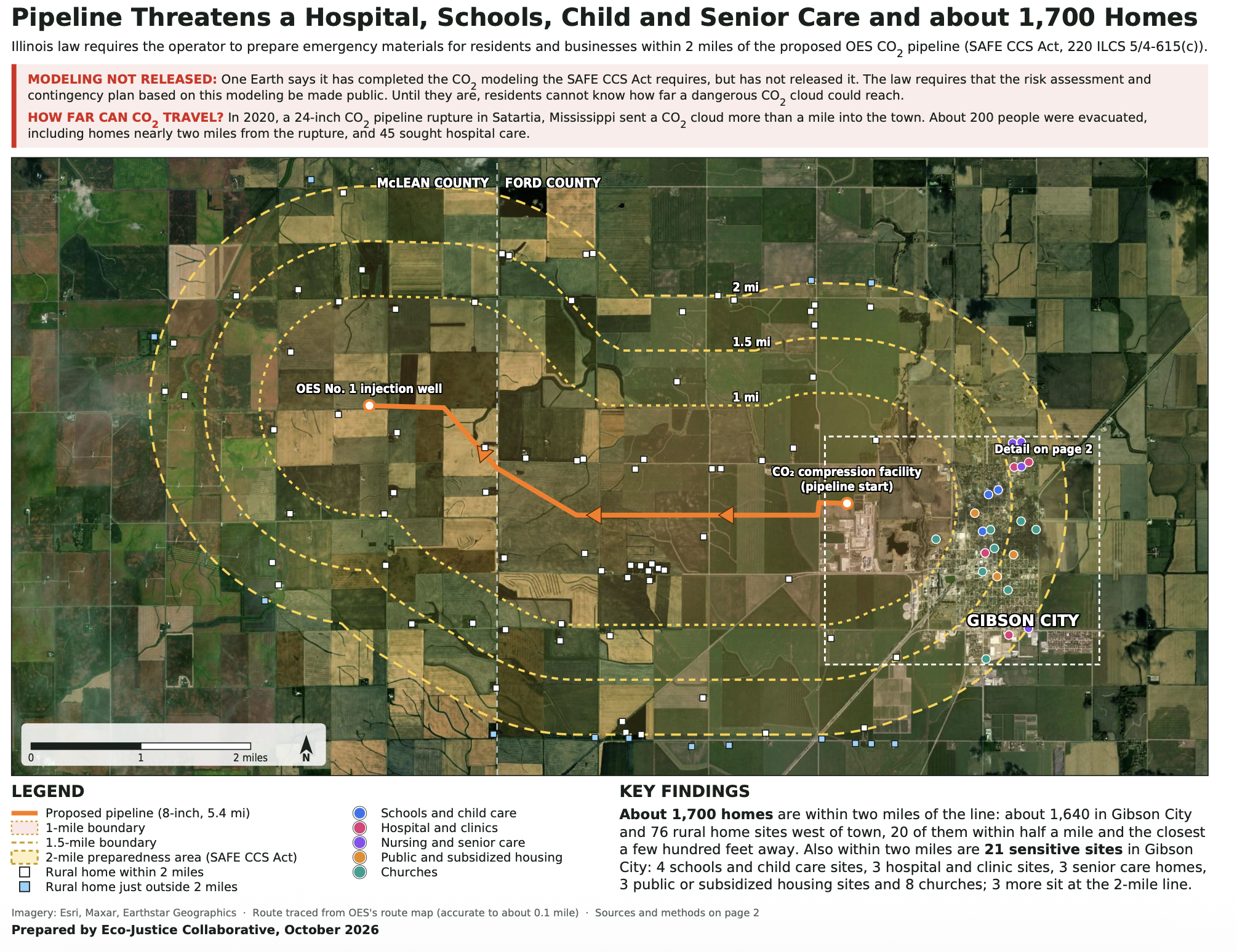
Champaign, IL—If the CO₂ pipeline near your home ruptured, would your family be safe? Could anyone reach you in time? Families in about 1,700 homes within two miles of the line have no way to know. One Earth Sequestration (OES) has not released the modeling or risk assessment that would answer those questions, but it still plans to hold its second round of required public meetings on the pipeline this Thursday, October 15, in McLean County. At the 5:30 p.m. meeting, Eco-Justice Collaborative and area residents will present a map showing the pipeline's path and the emergency planning zone.
McLean County meetings
- When: Thursday, October 15, 2026, at 5:30 pm. (OES is also holding a 10:30 am session.)
- Where: McLean County Fairgrounds, Mini-Expo Building, 1106 Interstate Drive, Bloomington, IL 61705
The proposed 8-inch, 5.4-mile pipeline would carry CO₂ from One Earth Energy’s compression facility on the west edge of Gibson City in Ford County to its planned injection well No. 1 in McLean County.
Not like an oil or gas pipeline
CO₂ is colorless and odorless. If a CO₂ pipeline leaks or ruptures, it can create a plume that displaces oxygen and is toxic at high concentrations, harming or even killing people and animals. The plume can also stall gasoline and diesel engines. People may not be able to drive away, and first responders may not be able to reach those in its path without electric vehicles.
The National Institute for Occupational Safety and Health (NIOSH), part of the Centers for Disease Control and Prevention, sets 15 minutes at 30,000 parts per million (ppm) as the most anyone should be exposed to. At 40,000 ppm, CO₂ is immediately dangerous to life and health. Without modeling that shows what concentrations could reach homes and other buildings, how long exposure would last, and how quickly the CO₂ would arrive, no one within the two-mile planning corridor can know whether they will be safe. And without the required risk-based assessment, no one knows whether they can be rescued in time.
The danger is real. On February 22, 2020, a CO₂ pipeline ruptured about a mile outside Satartia, Mississippi. The CO₂ cloud traveled more than a mile into town, and cars stalled. About 200 people were evacuated, including from homes nearly two miles from the rupture, and 45 sought hospital care. Federal investigators found that the operator's dispersion model had underestimated the area a rupture could affect, so no one in town had been warned.
What the public hasn't yet been shown
At the first round of meetings in Ford County on October 7, OES presented no information on CO₂ concentrations, length of exposure, or how quickly CO₂ would travel in a leak or rupture. It presented nothing on how first responders would rescue people in time. The pipeline route wasn't even shown on the company's slides. OES's website has placeholders for executive summaries of its risk-based assessment, plume modeling, and chemical safety contingency plan, but no documents.
Download this map to see what lies within two miles of the route, the zone where the SAFE CCS Act requires the operator to prepare emergency information for residents and businesses. The “unsafe zone” includes about 1,700 homes: about 1,640 in Gibson City and 76 rural home sites west of town, 20 of them within half a mile of the line and the closest a few hundred feet away. Also within two miles are 21 sensitive sites in Gibson City: four schools and childcare sites, three hospital and clinic sites, three senior care homes, three public or subsidized housing sites, and eight churches. GCMS High School is 1.29 miles from the line, and Gibson Area Hospital and ER are 1.56 miles away. The two-mile zone is not a modeled danger zone, because One Earth has not released its modeling.

“My home and farm are just a mile from where One Earth wants to put this pipeline,” said Sally Lasser, who farms her land outside Gibson City and plans to develop a retreat and education center there. “If it leaks or ruptures, I could be affected, and so could people living in 75 other rural homes within the two-mile emergency planning area. The only map we have that shows who lives there was prepared by Eco-Justice Collaborative, not One Earth. And if insurers decide a CO₂ pipeline so close to, or one that passes through our properties, is too big a risk, how do we protect our farms and businesses?”
“I’m just as worried about Gibson City, with its schools, hospital, nursing homes, public housing, churches, and another 1,600-plus homes within two miles of the pipeline,” Lasser said. “One Earth hasn’t shown us how far a CO₂ plume could travel or how strong it would be when it reached us. In fact, it hasn’t shown us anything we can use to judge the risk. One Earth needs to release its modeling and come back to Ford and McLean counties to show each of us how we would be affected by a CO₂ pipeline leak or rupture and how we’d be rescued in time.”
Why these meetings matter
The meetings are required by the Illinois Carbon Dioxide Transportation and Sequestration Act, which was amended as part of the SAFE CCS Act in July 2024. Before a company can apply to the Illinois Commerce Commission (ICC) for a CO₂ pipeline, it must hold at least two public pre-filing meetings in each county the pipeline would cross. The meetings are meant to introduce the route to landowners, residents, businesses, and institutions such as schools, hospitals, and churches; to answer their questions; and to take comments that could change the route. The intent is that any route filed with the ICC has considered its impacts and minimized harm.
But OES has limited each speaker to two minutes and has decided not to answer any questions at the meetings. It says it will post questions, comments, and responses on its website. Without key information on what could happen in a leak or rupture, those comments and responses will have little effect on the route.
"The SAFE CCS Act gives the public a chance to shape this route before it goes to the ICC," said Pam Richart, co-director of Eco-Justice Collaborative. "But you can't comment meaningfully on a route when the company won't say how far a CO₂ plume could travel, how high the concentrations would be, or how anyone would get you out if the pipeline were to rupture or leak. Two minutes at a microphone, with no answers, and no map of the pipeline isn't what the law intended. We urge everyone who lives or works near this route to come to the 5:30 meeting and put their concerns on the record."
What to expect at the 5:30 p.m. meeting
EJC and area residents will publicly present organized comments based on this map, highlighting the need for OES's modeling information and risk assessment. They will share what information is needed so that everyone living or working within the two-mile zone can determine whether they would be safe and rescued in time if exposed to dangerous levels of CO₂.
Because OES will not answer questions at the meetings, attendees are encouraged to ask that their questions be answered in writing, posted publicly, and included in the record the company files with the Illinois Commerce Commission.
About Eco-Justice Collaborative
Eco-Justice Collaborative is an Illinois nonprofit working for environmental justice and a healthy climate. EJC worked to pass the SAFE CCS Act and is a participant in the ICC's rulemaking to implement the Act's CO₂ pipeline provisions.
Contact: Pam Richart, Co-Director, Eco-Justice Collaborative · prichart@ecojusticecollaborative.org · 773.556.3418
###